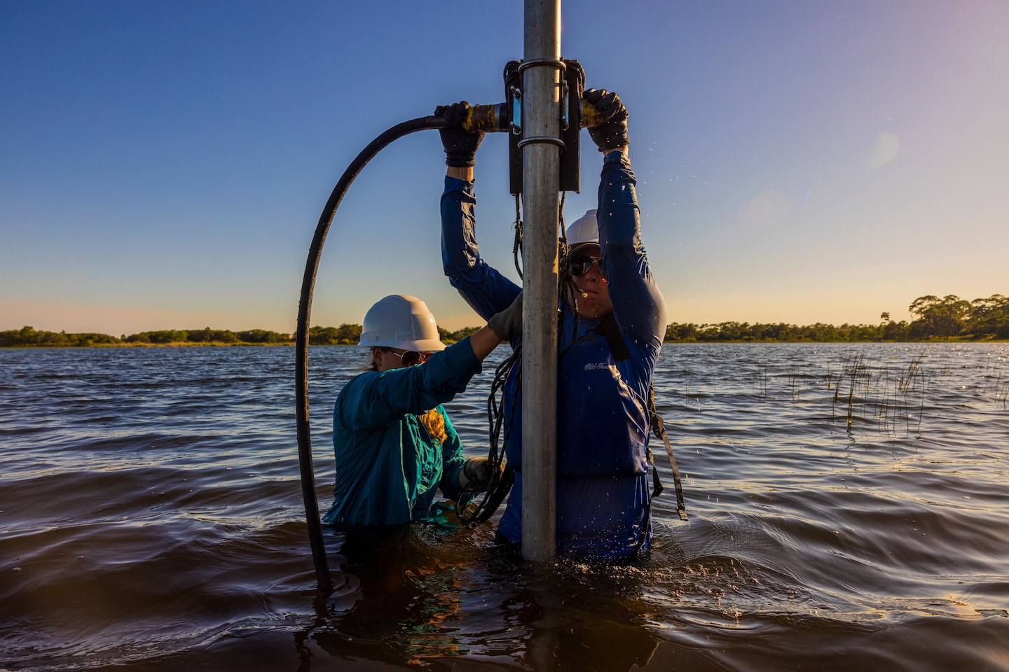
Aboard a small pontoon, Elliott went low to guide a stiff plastic tube vertically underwater while her colleague Josh Bregy raised and lowered a metal pile driver above her helmet-covered head — thing! thing! thing! — to embed the pipe deep into the lake bed.
After hours on the water, they hoisted an 18-inch cylinder from the bottom of the lake. Wedged between patches of mud was what Elliott was looking for: a layer of sand, the potential remnants of a deadly storm that had hit the Florida Panhandle.
“It’s a beautiful example of a hurricane layer,” she said, sliding her finger through the clear tube.
This muddy, dirty work is part of a field of study called paleotempestology, the study of ancient hurricanes. The burgeoning and relatively new science seeks to understand the storms that struck this and other coastlines before humans began recording the weather with modern instruments.
What researchers have found in that ancient mud so far offers a warning. By combing through the sediment, paleotempestologists have discovered periods when intense storms hit the coastline more often than current records show. Their work suggests that oceans are capable of producing hurricane seasons far more brutal than anything modern society has seen.
By burning fossil fuels and pumping heat-trapping gases into the air, the world now risks creating these stormier conditions again. Forecasters have already predicted that this year’s hurricane season, which started on June 1, could be among the worst in decades. Hurricane Beryl, which became a dangerous Category 4 hurricane on Sunday, is expected to sweep across the Caribbean this week.
If the past “is any indication of what we will see,” Elliott said, “our coastal areas are really vulnerable.”
The hunt for ancient hurricanes
In 1989, Kam-biu Liu, a professor at Louisiana State University, was giving a lecture on the layers of ash left on the bottoms of lakes by volcanic eruptions. A student, Miriam Fearn, asked if scientists could also see the tracks of hurricanes.
“That got me thinking. I said, ‘Sure, that should be possible,'” Liu said. That summer, he and Fearn found a layer of sand deep beneath an Alabama lake, left behind by a 1979 storm.
Paleotempestology got a boost after Category 5 Hurricane Andrew hit the Bahamas, Florida and Louisiana in 1992, killing dozens and causing billions of dollars in damage. The reinsurance sector, which financially supports home insurers and other insurance companies, invested money in prehistoric hurricane research to better understand the risk of major storms.
“They really delivered on their money and really got the field going,” said Jeff Donnelly, another ancient hurricane researcher at the Woods Hole Oceanographic Institution.
To predict how hurricane patterns will change in response to rising temperatures, climate scientists don’t have much to go on: about 170 years of instrumental data, a blink of an eye in Earth’s history. Paleotempestology promises to extend storm history by thousands of years and paint a more complete picture of how bad hurricanes can get.
When an intense hurricane makes landfall, water crashes onto beaches and carries waves of sand inland. If a lake is located right along the coast, that material washes into it and settles on the bottom. By measuring radioactive carbon in those layers, paleotempestologists can figure out when a storm hit.
Over time, the coarse beach sand deposited by storms becomes encapsulated in mud or wedged between layers of finer sand. In general, the more intense the storm, the coarser the sand, because more force is needed to sweep heavier grains toward lakes.
Spotting a sandy hurricane layer among a pile of other sand can be difficult, like “finding hay in a haystack,” Elliott said.
Elliott knows perseverance. She grew up in Michigan and helped her father build houses during summer vacation while he studied geology. She said she had tense conversations about climate change with her more conservative father.
But recently she took the time to walk him through the data and answer his questions. “We just sat down and talked about it,” she said. “And now we’re at a point where at least he’s more willing to have the conversation and acknowledge that things are changing.”
Here at Campbell Lake, in At Florida’s Topsail Hill Preserve State Park, only a thin edge of blinding white sand separates the freshwater body from the Gulf of Mexico. This is one of the few places in the world with dune lakes on the coast. Elliott, an emerging ancient hurricane researcher, thought it was a perfect place to look for signs of ancient storms.
“Coastal lakes are by far our favorite place to core,” she said.
After embedding the tube in the lake bottom, Elliott and Bregy, a scientist at Clemson University, took turns cranking a winch and pulling the cylinder by hand to retrieve a sample of the lake’s valuable sediment.
“This must be mud,” Bregy said. “Keep going, keep going, keep going,” Elliott urged. “It has to come out.” That first, 1½-foot core contained a sand layer from a relatively recent storm, probably Hurricane Opal in 1995.
To find older storms, the team had to dig deeper into the lake bottom – and into the past. With no motor for the pontoon, Elliott and Bregy had to rely on their students in kayaks and a canoe to pull the boat across the 100-acre lake.
Far from the shady pine trees along the lake’s edge, the small armada pulled the pontoon toward the center the lake. Another group of students sat on the shore — looking for alligators.
“Watch your head,” Bregy said before he started to ding, ding, ram another hollow plastic tube into the bottom of the lake. Exhausted, he began to imagine what he would eat that evening. “I’m going to get ice cream tonight,” he said. “I’m going to get some strawberries.”
The next two cores were larger: about 3 feet and 13 feet long. The longer one likely dates to more than 10,000 years ago, Bregy said. Their chalky odor suggested they contained marine microfossils rich in calcium carbonate, which can tell researchers what layers have washed ashore from the ocean.
Once back on dry land, Elliott and Bregy high-fived.
Other Gulf Coast sediment cores show a period of intense hurricane activity in the region – worse than what we see today. It lasted for centuries before ending abruptly about 600 to 800 years ago.
What caused storms to rage and then subside? One theory is that a change in the position of a high-pressure area over the Atlantic Ocean, called Bermuda High, pushed storms from the Gulf Coast to the East Coast. That would explain why New England lakes are recording an increase in storms just after hurricane activity decreased along the Gulf Coast.
Another factor is a flood of warm water called the Loop Current that flows through the Gulf of Mexico. It once flowed close to the coast before sliding south into the Gulf, a shift that lowered water temperatures and robbed storms of wind-blasting energy.
The fact that the surface temperature of the Gulf of Mexico is currently rising again due to climate change is concerning for researchers of ancient hurricanes.
“What these data clearly show is that, absent human intervention, the climate system can already adjust itself in ways that are giving us activity that we haven’t seen in the past century or so,” Donnelly said. “The big question is, now that we are turning the dial on climate, what is the likely outcome?”
To find the answer, paleotempestologists are looking beyond the sand layers to other evidence of hurricanes: exploring caves for drip deposits formed by cyclonic rain, searching lakes for storm-washed coral blocks, scouring libraries for newspaper clippings, ship logs and diary entries for accounts of hurricanes.
“If you have different techniques and they work together,” Liu said, “then that might be the best approach.”
Much of Elliott and Bregy’s work focuses on tree rings. Hurricanes leave subtle marks on coastal trees – if they aren’t blown down, that is – while their rings record extreme precipitation and saltwater flooding from the past.
Bregy goes to great lengths to find old wood, pulling it from leftover stumps and even from dug-up coffins. He recently got a tetanus shot after being pricked by a rusty nail while sampling wood in an old attic.
“The problem here in the eastern U.S. is there’s been so much logging,” Bregy said. “It’s hard to find old living trees.”
Back on shore, Elliott knelt and used a power tool to cut one of the sediment cores in half. A thin strip of plastic curled as she guided the device along the length of the tube. She was always ready to offer a lesson and help one of her students get the job done.
“Beautiful,” she said, complimenting his work. He paused, but she urged him on. “You are good, you are good.”
A series of dark bands in the bisected sediment core could be hurricane layers, though only a thorough lab analysis will reveal the truth. Elliot and Bregy’s labs will search for marine fossils, measure sand grain size and analyze isotope levels to gauge the intensity of ancient storms and figure out when they hit.
“This is the beginning of our work,” Elliott said.
At her hotel after a day of work at Campbell Lake, Elliott called her father. “‘What did you see? What did you learn?'” she recalled him asking.
Later in a telephone interview, Elliott’s father, Tony Timmons, acknowledged that the climate is changing, though he “can’t fathom that it’s all man-made.” If more scientists like his daughter were to address climate change, perhaps people would be more willing to accept it.
“Em will explain things to me and that makes it interesting for me, and I understand it,” he said.
He added: “What she does is important.”