
A team led by glaciologists from UC Irvine used satellite radar data to reconstruct the impact of warm ocean water rising in a grounding zone extending several kilometers beneath the Thwaites Glacier in West Antarctica. The research, the subject of an article published in PNAS, will help climate modelers derive more accurate projections of sea level rise due to melting ocean-closing glaciers around the world. Credit: NASA/James Yungel
Satellite radar data shows that there is significant seawater intrusion under Antarctica Thwaites Glaciercausing ice to rise and fall.
Using high-resolution satellite radar data, a team of glaciologists led by researchers from the University of California, Irvine, has found evidence of the intrusion of warm, high-pressure seawater many kilometers beneath the grounded ice of the Thwaites Glacier in Western Antarctica. This glacier is often referred to as the ‘Doomsday Glacier’ due to its crucial role in potential global sea level rise and the catastrophic consequences such a rise would have worldwide. This nickname reflects the glacier’s enormous size and significant melt rate, which scientists believe could contribute substantially to sea level rise if it were to collapse or melt completely.
The UC Irvine-led team said widespread contact between ocean water and the glacier – a process repeated across Antarctica and Greenland – is causing “vigorous melting” and may require a reassessment of global sea level rise projections. Their research was published on May 20 in Proceedings of the National Academy of Sciences,
Data and observations
The glaciologists relied on data collected between March and June 2023 by the Finnish commercial satellite mission ICEYE. The ICEYE satellites form a “constellation” in a polar orbit around the planet, using InSAR (interferometer synthetic aperture radar) to continuously monitor changes on the Earth’s surface. Many passes by a spacecraft over a small, confined area produce smooth data results. In the case of this study, it showed the rise, fall and flexure of the Thwaites Glacier.
“These ICEYE data provided a long series of daily observations that closely matched tidal cycles,” said lead author Eric Rignot, professor of Earth system sciences at UC Irvine. “In the past, we had sporadically available data, and with only those few observations it was difficult to figure out what was going on. If we have a continuous time series and compare it with the tidal cycle, we see that the seawater enters and withdraws at high tide, sometimes penetrating further under the glacier and becoming trapped. Thanks to ICEYE, we are witnessing these tidal dynamics for the first time.”
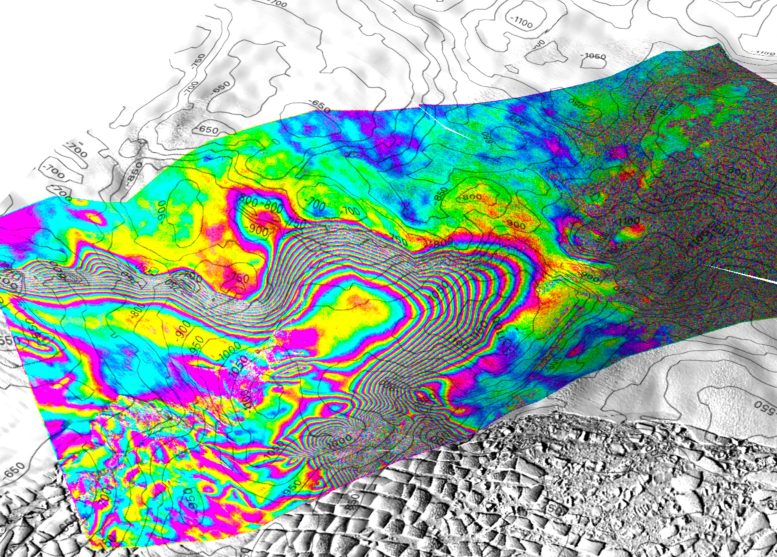
Screenshot of a 3D view of the tidal movement of Thwaites Glacier, West Antarctica, captured by the ICEYE Synthetic Aperture Radar (SAR) constellation, based on images acquired on May 11, 12 and 13, 2023. Contour levels are bottom topographic contours on 50 m distance interval. Each interferometric color cycle of the edge is a 360 degree phase change, corresponding to a displacement of 1.65 cm in line-of-sight distance from the ice surface. The interferogram is overlaid on a Landsat 9 image acquired in February 2023. In this study, we show that the limit of tidal bending varies per kilometer over the tidal cycle, indicating that pressurized seawater can penetrate beneath the grounded ice for kilometers and harden vigorously. heat exchange with the glacier base. On the right side of the screen, a separate bull’s-eye indicates that seawater intrusion is propagating another 6 km beyond a protective ridge, indicating that glacier retreat is still underway, at a rate of kilometers per year in this critical sector of Antarctica. Credit: Eric Rignot/UC Irvine
Advanced satellite observations
ICEYE Director of Analytics Michael Wollersheim, co-author, said: “Until now, some of the most dynamic processes in nature have been impossible to observe with enough detail or frequency to allow us to understand and model them. Observing these processes from space and using radar satellite images, which provide daily centimeter-level InSAR measurements, represents a significant leap forward.”
Rignot said the project helped him and his colleagues develop a better understanding of the behavior of seawater at the base of the Thwaites Glacier. He said seawater entering at the base of the ice sheet, combined with freshwater generated by geothermal flux and friction, accumulates and “has to flow somewhere.” Water is distributed through natural conduits or collects in cavities, creating enough pressure to raise the ice sheet.
“There are places where the water is almost at the pressure of the overlying ice, so it takes just a little bit more pressure to push the ice up,” Rignot said. “The water is then compressed enough to lift a column of more than half a mile of ice.”
And it’s not just any seawater. For decades, Rignot and his colleagues have been collecting evidence about the impact of climate change on ocean currents, which drive warmer seawater to the coasts of Antarctica and other polar ice regions. Circumpolar deep water is salty and has a lower freezing point. While fresh water freezes at zero degrees Celsiussalt water freezes at minus two degrees, and that small difference is enough to contribute to the “forceful melting” of basal ice, the study shows.
Impact on sea level rise and future research
Co-author Christine Dow, professor at the Faculty of Environment at the University of California University of Waterloo in Ontario, Canada, said: “Thwaites is the most unstable place in Antarctica and contains the equivalent of 60 centimeters of sea level rise. The concern is that we are underestimating the rate at which the glacier is changing, which would be devastating to coastal communities around the world.”
Rignot said he hopes and expects that the results of this project will lead to further research into conditions under the Antarctic glaciers, exhibitions with autonomous robots and more satellite observations.
“There is a lot of enthusiasm from the scientific community to go to these remote, polar regions to collect data and build our understanding of what is happening, but funding is lagging,” he said. “We will be operating with the same real dollar budget in 2024 as we did in the 1990s. We need to expand the community of glaciologists and physical oceanographers to address these observational problems sooner or later, but right now we are still climbing Mount Everest in tennis shoes.”
Conclusion and implications for modeling
In the short term, Rignot, who is also a senior project scientist at NASA‘s Jet Propulsion Laboratory (JPL), said this study will provide lasting benefit to the ice sheet modeling community.
“If we put this kind of ocean-ice interaction into ice sheet models, I expect we will be much better able to reproduce what has happened over the past quarter century, leading to a higher level of confidence in our projections,” he said. “If we could add this process that we outlined in the paper, which is not included in most current models, the model reconstructions should fit the observations much better. It would be a big victory if we could achieve that.”
Dow added: “Right now we don’t have enough information to say one way or another how much time is left before ocean water intrusion is irreversible. By improving the models and focusing our research on these crucial glaciers, we will try to lock in these numbers for at least decades rather than centuries. This work will help people adapt to changing ocean levels, and will focus on reducing CO2 emissions to avoid the worst-case scenario.”
Reference: “Widespread seawater intrusions beneath the grounded ice of Thwaites Glacier, West Antarctica” by Eric Rignot, Enrico Ciracì, Bernd Scheuchl, Valentyn Tolpekin, Michael Wollersheim and Christine Dow, May 20, 2024, Proceedings of the National Academy of Sciences.
DOI: 10.1073/pnas.2404766121
Rignot, Dow and Wollershiem were joined on this project by Enrico Ciraci, UC Irvine assistant specialist in Earth system science and NASA postdoctoral researcher; Bernd Scheuchl, UC Irvine researcher in Earth system science; and Valentyn Tolpekin of ICEYE. ICEYE is headquartered in Finland and operates from five international locations, including the United States. The research received funding from NASA and the National Science Foundation.